Walks & Parks
-

Mt. Damper Falls
This is one of the tallest waterfalls in the North Island. This is a short walk, 30 min return, and makes a great stop along the Forgotten Highway.
read more-
Location:
Mount Damper Falls
Ahititi
-
Location:
Mount Damper Falls
-

Taupo - Lions Walk
This magnificent walk was formed by the Taupo Lions Club and is an easy, level walk on a pathway bordering the lake edge. The walk follows the lakeshore south where kowhai trees provide shelter for local wildlife including ducks and swans.
read more- Location: Two Mile Bay Boat Ramp
-

Timaru Botanic Garden - Timaru
One of the oldest Botanic Gardens. The species roses in the Timaru Botanic Garden have received national recognition. Highlights include the Graeme Paterson Conservatory, ponds and threatened plant collections.
read more- Location: Corner of King and Queen Street, Timaru
-

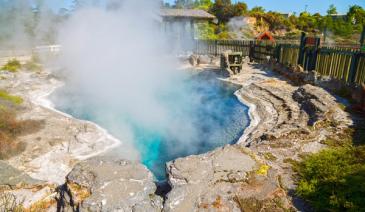
Rotorua - Butcher’s Pool
This free hot mineral pool has recently been upgraded. The mineral water is piped directly from an adjacent spring. As with all hot pools, it is advisable that you keep your head above water at all times to avoid the risk of contracting amoebic meningitis. Toilets and changing rooms are on-site.
read more- Location: Broadlands Road, 1.8 km south of Reporoa Village.
-

Waihi Beach
Waihi beach is one of the safest surf beaches in New Zealand. There is plenty of room to relax and play on the nine kilometers of beautiful, white sand. There is a modern shopping centre close by with restaurants.
read more- Location: Waihi, Coromandel/Bay of Plenty
-

Alexandra - Clyde River Track
This Central Otago walk follows the Clutha River on the true right bank between Alexandra and Clyde. Although graded as ‘easy’ it is 12.8km and will take 3-4 hours to complete. It is a popular walking and cycle track, with sections suitable for pushchairs or wheelchairs. The track stays within 20 meters of the river and mostly in the shade of large willow trees. A fantastic walk or bike with the kids for a day out and especially good in the height of summer when shade is appreciated. There are numerous spots to stop and picnic or just enjoy the ambiance.
read more- Location: Earnscleugh Bridge
-

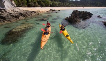
Port Chalmers Recreation Reserve - Dunedin
Follow the Port Chalmers road alongside the harbour to this tiny seaside township. There are a number of pathways around the cemetery, providing good views of Careys Bay. For a great beach/picnic spot, follow the Blueskin Road by car, to the beach and river at Purakaunui. Fantastic swimming hole, and fun for kayaks.
read more- Location: Dunedin - Port Chalmers
-

Hawkes Bay - Pourerere Beach
Ideal for fishing, swimming and surfing, Pouerere Beach has a camping ground and freedom camping areas. The safe swimming beach has golden sand and dolphins and seals are sometimes seen in the bay. There are toilets and changing rooms on the right side of Pouerere Road.
read more -

Halswell Quarry Park
A unique, 55 hectare family-orientated park on the outskirts of Christchurch. The disused quarry makes for an interesting (and fenced off) stroll, with its striking amphitheatre of steep, jagged rock walls. There’s plenty of grassy spots and picnic areas to spread out and play, plus loads of walking and bike tracks that wander through woods and orchards. Take a walk through the ‘sister-city’ gardens, with Korean statues and bridges. Toilets and water on-site. To get there from Halswell, take Kennedys Bush Road south toward the hills. A marked turnoff at the base of the foothills leads into the park. A lake on the left is surrounded by the new plantings of the Sister Cities' Gardens, and on the right, the abandoned buildings of the quarry are visible.
read more- Location: Christchurch - Halswell
-

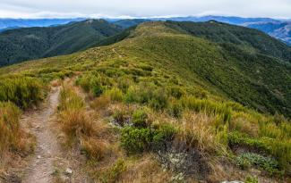
Alice Nash Memorial Heritage Lodge Track - Palmerston North
This track in the scenic Oroua River valley can be enjoyed as a half day tramp but it's also a good overnight tramp for families with children and new trampers. To get to the hut it's only about an hour each way and the views up the Oroua River and the surrounding ranges are spectacular
read more-
Location:
Table Flat Rd
Apiti 4774
-
Location:
Table Flat Rd
-

Scorcher Bay
This popular sun-bathing beach is very sheltered, with a large grassy area, sandy beach and great views. Refreshments are available at the Chocolate Fish café nearby, a family friendly café offering all day breakfasts and paninis as well as smoothies, salads and pasta.
read more- Location: Miramar Peninsula
-

Hokitika Gorge Walk
Just a short 15 min walk takes you to excellent views of the blue-green waters of the Hokitika River as it makes its way through the rock sided Hokitika Gorge - this short, easy walk is a great option for kids. From the car park, follow the walking track for a few minutes through dense podocarp/hardwood forest before emerging onto a viewing platform. From here you can look down to the stunning Hokitika Gorge and out to the lush farmland of Kowhitirangi. This part of the track is accessible for wheelchairs. From the viewing platform, continue for another 6 minutes along the curving boardwalks and you will reach a swing bridge. From here there are excellent views of the blue-green waters of the Hokitika River as it makes its way through the rock sided Hokitika Gorge. For good views further up the gorge, cross the swing bridge and when you come to the end of it turn left (straight ahead leads to private farmland). The track continues for another 200 m through the bush to another viewing platform with looking out to the gorge upstream of the bridge.
read more- Location: Whitcombe Valley Rd, Hokitika Gorge, Kokatahi 7881
-
Mt. Thomas Conservation Area
The Mt. Thomas Conservation area offers a wide variety of trails making this an ideal destination to spend a few hours or an entire day exploring. Options included the Kereru Track which is an hour return to longer missions to the Mt. Thomas Summit - 3 hours one way.
read more- Location: 392 Glentui Bush Rd, Glentui 7495
-

The Esplanade Picnic Area - Queenstown
A favourite spot, only minutes from the town centre. There’s lots of space as the picnic area runs alongside the lake for about 1km. Close to playground and toilets.
read more- Location: Queenstown - The Esplanade
-

Jubilee Park - Dunedin
Starts at Jubilee Park, just a few blocks South West of the city centre. This easy, casual track follows the bush on the flanks of the sports ground. Suitable for buggies. Toilets on-site. Parking off Maori Road.
read more- Location: Dunedin - Maori Road, off Serpentine Ave
-

Hawkes Bay - White Pines Bush
29km north of Napier on SH2, native bush walk with educational panels, native birds and forest. The reserve has huge kahikatea, dwarfing the tawa and pukatea that provide most of the remaining tree cover. Nikau palms are also an attraction. Hanging vines, shrubs and ferns proliferate under the tree canopy, providing habitat for native birds including tui, kereru (native pigeons), fantails, bellbirds, silver-eyes, grey warblers and ruru (morepork). Boardwalks make it easy with buggies and there are two walks to choose from – 30 minutes or 1 hour. Toilets and picnic area.
read more- Location: SH2, 29km north of Napier
-

Rapaura Watergardens - Thames Coast
Abundant native bush, ferns, watergardens and birds. Wander over bridges and take a bush walk to a cascading waterfall. The seasonal displays of native and exotic flowers are interspersed with garden art. Most of the Gardens are accessible by pushchair, except for the last part of the walk to the falls where there are long steps. It takes about 45 minutes to wander around the Gardens. Take a picnic - there are picnic tables in the car park and ducks and chickens waiting to be fed!
read more- Location: 586 Tapu Corodlen Road, Tapu Village, Thames Coast
-

Ruakuri Walkway - Waitomo
The 45 minute return journey is over a well-constructed track which passes through picturesque rain forest and limestone landscale with excellent views of the Ruakuri Natural Tunnel (a remnant cave). There are picnic tables and toilets at the start of the walk.
read more- Location: 3 Kilometres from Waitomo Museum, off Tumutumu Road
-

Waterfall Track - Hamner
Climb through mountain beech forest to the spectacular 41 metre high Dog Stream Waterfall. The winding and moderately steep trail begins at the top of McIntyres Road (accessed off Jollies Pass Road) and heads up the stream edge through dense native forest. The walk is interesting and varied as it traverses the watershed just above the deep gutter of Dog Stream, (parents with young children need to take care at several places along this track), climbing up wooden stairways in the forest and sidling along small cliff faces to reach the rock face and small basin into which the waterfall plummets. A suggested round trip is to return via the Spur Track and Fir Trail.
read more- Location: McIntyres Road (accessed off Jollies Pass Road), Hamner
-

Curio Bay - Catlins
Curio Bay is of international significance for its fossilised forest dating back to the Jurassic period. The tree fossils you see here are 160 million years old and the forest was alive when NZ was part of Gondwanaland. Curio Bay’s fossil forest is best viewed at low tide from the viewing platform which is only a short walk (5 minutes) from the car park.
read more -

Waitahinga Trails Whanganui
A range of walks in wild, native bush. The Waitahinga Trails are located about 12 kms past Bushy Park, inland from Kai Iwi Beach, and are a collection of walks in native bush catering for various fitness levels. There are various walks of different lengths that make a great half day or full day outing in the hinterlands of Whanganui!
read more-
Location:
Rangitatau East Road
(Junction Road)
Kai Iwi, Whanganui.
-
Location:
Rangitatau East Road
-

Chatterton River Track
2 hr 30 min return. The Chatterton River Track provides something a little different to the other walks in the Hanmer Forest region in that it is less visited, a little remote, and has an seclusion not easily found along the more popular walks. Beginning on Chatterton Road, about 1.2km north of the Alpine Adventure Camp (there is a gate here that is sometimes locked making it necessary to walk this section as well), the track heads down to the stream which it then follows all the way to the valley head. Higher up mature stands of mountain beech will be encountered as well as groves of ferns and some relatively steep sections of track as the route makes its way up the south face of Jacks Pass to the broad summit. At the pass there is a spectacular view here of the Hanmer Range peaks and over into the Clarence Valle.
read more- Location: Chatterton Road, about 1.2km north of the Alpine Adventure Camp
-

Takaka Hill Walkway
Takaka Hill Walkway is a loop walk at the top of Takaka Hill. The walkway passes through fascinating karst landscape, with intriguing marble rock formations, beech forest with magnificent views of Kahurangi National Park and Golden Bay. Length: 3 km for half loop; 5.1 km for full loop, Time Required: 1-2 hr for half loop; 2-3 hr for full loop. The loop track is located at the top of Takaka Hill on State Highway 60, 53km from Richmond and 38 km from Takaka. There is a car park off the side of the road which is well signposted.
read more- Location: 1147 Takaka Hill Hwy, Takaka Hill 7198
-
Bushy Park Wildlife Sanctuary
Bushy Park Reserve is a 100 hectare native forest sanctuary kept predator‑free for native birds and is ranked one of Australasia’s ‘Top 25’ Restoration Projects. There are 3.4km of easy all‑weather walking tracks throughout the forest and a huge variety of bird life and species of trees. Don’t miss ‘Ratanui’, believed to be the biggest northern rata, 43 metres high with a girth of more than 11 metres with an age of between 500 and 1000 years. Free entry, daylight hours.
read more
While you’re there, visit the 22 room 1906 Edwardian‑era homestead and enjoy a picnic.- Location: 791 Rangitatau East Road, Wanganui
North Island
South Island

- Central Otago
- Auckland
- Bay of Plenty
- Christchurch
- Dunedin
- Coromandel
- Gisborne
- Fiordland
- Hawkes Bay
- Marlborough Sounds
- Manawatu
- Nelson & Golden Bay
- Northland
- North Canterbury
- Queenstown
- Rotorua
- South Canterbury
- Taranaki
- Southland
- Taupo
- Wanaka
- Waikato
- Wellington
- West Coast
- Whangarei
- Bay of Islands
- Tauranga
- Gisborne
- Hamilton
- Napier
- Kapiti
- Palmerston North
- Whanganui
- New Plymouth
- Arrowtown
- Te Anau
- Akaroa
- Ashburton
- Hanmer
- Kaikoura
- Methven
- Mt Cook
- Oamaru
- Tekapo
- Timaru
- Abel Tasman
- Motueka
- Nelson Lakes
- Blenheim
- Picton
- Catlins
- Gore
- Stewart Island
- Central Plateau
- Invercargill
- Cromwell
- Greymouth
- Hokitika
- Westport
- Glenorchy
Our favourite destinations…